Labuan Bajo to Riung: Road, Time and the Real Drive
Riung Flores Editorial Desk 13 min read
Road and safety status, updated 25 August 2026. The magnitude 7.7 earthquake of 15 August 2026 caused confirmed damage in Riung, and landslides blocked the Ende–Bajawa stretch of the Trans-Flores highway, with clearance assigned to Indonesia’s Ministry of Public Works. Aftershocks were still being recorded when this note was written. The times and routes below describe normal conditions — confirm the current status of your road before you travel. Sources and the latest entry are on the 2026–2027 updates page.
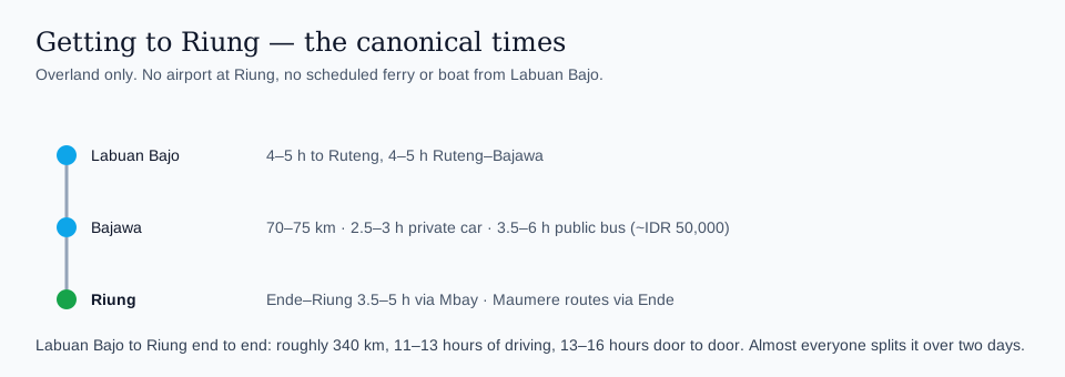
Labuan Bajo to Riung is about 340 km by road, roughly 11–13 hours of actual driving and 13–16 hours door to door once you add meals and fuel stops — and it’s the longest, least-discussed leg of any Flores itinerary that tries to combine both destinations. Here’s what the drive actually involves.
How far is Riung from Labuan Bajo?
The road distance between Labuan Bajo and Riung is roughly 340 km, following the Trans-Flores highway east through Ruteng and Bajawa before turning north to the coast at Riung. It breaks into three mountain legs — Labuan Bajo to Ruteng, Ruteng to Bajawa, then the 70–75 km spur down from Bajawa to the north coast. The straight-line distance is far shorter, but Flores’s mountainous interior means the actual road winds considerably more than a map suggests.
How long does the drive really take?
Longer than any single online estimate suggests, because no routing engine models the Flores highlands well. Budget 11 to 13 hours of actual driving in a private car: roughly 8 to 10 hours from Labuan Bajo through Ruteng to Bajawa, then another 2.5 to 3 hours down the spur to Riung. Add meal and fuel stops and the realistic door-to-door figure is 13 to 16 hours, which is why almost nobody does it in one push. Public buses and shared travel vans run longer still, since they stop repeatedly to pick up and drop off along the way. If you insist on a single day, leave before dawn with a driver who knows the road, and accept that you will arrive after dark.
What’s the road condition like?
The main Trans-Flores highway is mostly paved, but it’s a genuinely mountainous route — narrow in sections, with frequent curves through the highlands around Ruteng and Bajawa, and variable surface quality including occasional potholes and roadworks. The spur road down from the main highway to Riung on the north coast is described by Indonesian tourism sources as particularly winding (“berkelok-kelok”), which is part of why travel times run longer than the map distance implies. This isn’t a road to drive fast on, and it isn’t one to attempt for the first time after dark.
Should I go by bus, shared travel, or private car charter?
Each option trades cost against time and comfort. A private car or driver costs more but gives you control over departure time, rest stops, and the ability to break the journey if needed. Shared travel vans (often called “travel” locally) cost less but run on their own schedule and make more stops. Public buses are the cheapest option but the slowest and least flexible, with the least predictable departure times. For travelers on a tight schedule trying to combine Riung with a Komodo National Park visit, a private car is usually worth the extra cost simply to protect the rest of the itinerary from a delay on this one long leg.
Can I break the journey into two days?
Yes, and for many travelers this is the more comfortable option. Bajawa, roughly midway along the route, is a common overnight stop — it also happens to be the gateway town for visiting traditional Ngada villages and, further afield, the Wawo Muda volcanic crater. Breaking the drive at Bajawa turns one very long travel day into two manageable ones and adds a genuine attraction to the itinerary rather than just a rest stop.
| Mode | Typical time, Labuan Bajo to Riung | Trade-off |
|---|---|---|
| Private car/driver, direct | ~11–13 hours driving, 13–16 door to door | Fastest and most flexible, highest cost |
| Shared travel van | ~15 hours or more | Cheaper, but fixed schedule and many more stops |
| Public bus | Longer than shared travel, variable | Cheapest, least predictable timing |
| Split via Bajawa overnight | ~2–3 hrs + overnight + ~2–3 hrs | More comfortable, adds a genuine stop, costs one extra night |
Source: Rome2Rio route data (2025), Indonesian tourism sources on Trans-Flores road conditions. Terakhir diperbarui: 25 Agustus 2026.
Is it too far for a day trip from Labuan Bajo?
Yes, honestly. A round trip alone would consume 9–12+ hours of driving, leaving little to no time to actually enjoy Riung’s marine park. Riung is not a viable day trip from Labuan Bajo — it needs at least one overnight stay in Riung itself, and ideally two, to make the long drive worthwhile. If your schedule genuinely can’t accommodate an overnight in Riung, it’s more honest to skip it than to attempt a rushed round trip that leaves you exhausted and short on actual time at the destination.
What should I do before the drive?
Fuel up, withdraw cash (ATM access becomes unreliable once you’re past the larger towns), and download offline maps — mobile signal drops out in stretches of the mountain highway. See our full packing guide for what else to bring, and our cost breakdown for what to budget once you arrive.
Which direction should I travel — Riung first or Labuan Bajo first?
This depends more on your flight routing than the drive itself, since the road distance is identical either direction. See our dedicated guide on whether to visit Riung or Labuan Bajo first for how to decide based on where your flights land.
If your trip’s main focus is Komodo National Park rather than Riung, and you’re weighing whether the long detour to Riung is worth it at all, Komodo Luxury’s boat trip and Komodo tour from Bali packages give a sense of what a Komodo-only itinerary looks like without the Riung detour, for comparison.
What towns do you actually pass through on the way?
The route east from Labuan Bajo runs through Ruteng, the highland capital of Manggarai Regency known for its cooler climate and coffee plantations, then continues to Bajawa in Ngada Regency, the gateway to the region’s traditional villages, before the final spur north to the Riung coast. Each of these towns has basic services — fuel, food, simple lodging — making them realistic stopping points if you’re breaking the journey rather than driving it in one push. Ruteng in particular is a reasonable lunch stop even on a single-day drive.
What should I expect for fuel, food and rest stops along the way?
Fuel stations are available at reasonable intervals along the main Trans-Flores highway itself, though less so on the final spur road into Riung — top up before leaving the highway if your tank is low. Food options along the route are simple roadside warungs rather than anything resembling a highway rest stop in the Western sense; don’t expect much variety, but basic meals are available in the larger towns along the way. Build extra time into your schedule for these stops rather than assuming a straight-through drive at the estimated time — a realistic travel day includes at least one proper meal stop and a couple of shorter breaks.
How does this drive compare to other long overland legs in Flores?
This is one of the longer point-to-point overland legs commonly attempted by travelers on a Flores itinerary — longer than, for example, the Labuan Bajo–Ruteng or Bajawa–Ende legs individually, which is exactly why splitting it at Bajawa appeals to many travelers rather than attempting it in one sitting. If you’re already planning to see Bajawa’s traditional villages or continuing on to Kelimutu near Moni afterward, treating this as a multi-stop journey rather than a single long transfer makes both practical and itinerary sense.
What’s the elevation and terrain like along the way?
The route climbs well into Flores’s volcanic highlands through Ruteng and Bajawa before descending back to sea level at Riung’s north coast, meaning temperature swings across the journey — noticeably cooler in the highland towns than at either coastal end. This isn’t a flat coastal drive; expect genuine mountain-road driving with the elevation changes, curves and slower average speed that implies, which is part of why the time estimate runs longer than the raw distance suggests.
Frequently asked questions
Is there a flight closer to Riung than Labuan Bajo?
Riung doesn’t have its own commercial airport; the nearest useful airports are in Labuan Bajo (west) or via Bajawa/Ende (east), both still requiring a significant onward drive.
Can I rent a motorbike and ride to Riung myself?
It’s physically possible but not recommended for inexperienced riders — the mountain sections are genuinely demanding, with sharp curves, elevation changes and long stretches without services.
Is the drive safe at night?
We wouldn’t recommend it for a first-time visitor. The road’s curves, variable surface quality and limited lighting make a daytime departure the safer choice.
How much does a private car charter cost for this route?
Rates vary by driver and vehicle type and we haven’t found a fixed official tariff to cite; get a quote from your accommodation or a local operator before committing, and compare at least two quotes if possible.
Related reading
- Wisata 17 Pulau Riung: panduan lengkap
- Riung or Labuan Bajo first?
- 2-day Riung 17 Islands itinerary
- What a Riung 17 Islands trip really costs
Terakhir diperbarui: 25 Agustus 2026.
Practical driving details between Labuan Bajo, Bajawa, Kelimutu and Riung
On the map the Trans-Flores highway looks simple, but the reality is a sequence of mountain climbs, coastal drops and long stretches without services. This section answers recurring route-planning questions: how long does it take to drive from Labuan Bajo to Riung, and is the road safe, what the curves are like between Bajawa and Riung, and how Kelimutu fits into a wider Flores loop.
If you are still choosing between starting your itinerary in Riung before Labuan Bajo or ending there after visiting Komodo, read the comparison of sequence options in whether to visit Riung or Labuan Bajo first. Once you know your direction, you can pin down drive times and overnight stops with more confidence.
For nuts-and-bolts transport (bus names, typical ticket prices and how to actually buy seats on Riung to Labuan Bajo shared car travel), the broader island overview at getting to Riung from Bajawa, Ende and Labuan Bajo is a good next read. The notes below focus on real-world driving conditions, timing and how to link Riung with Kelimutu, Bajawa and Komodo without rushing every day.
What are the latest Labuan Bajo to Riung road conditions like in practice?
The Trans-Flores section out of Labuan Bajo is generally paved and maintained, but narrow with frequent trucks and local traffic. Surface quality improves after Ruteng, then becomes more mixed approaching Bajawa. The northern spur to Riung is where many ask whether the road to Riung is rough; it has patched sections and tight hairpins, yet is fully passable by standard cars in daylight and dry-season weather.
How long is the drive from Bajawa to Riung Flores, and what about curves and gradients?
Allow 2.5–3 hours for Bajawa–Riung by private car, depending on stops and weather; the public bus takes 3.5–6 hours over the same 70–75 km. The first hour out of Bajawa climbs and descends through cool highland forest, then the road drops towards the hotter north coast. The road down from Bajawa to Riung is manageable but continuously winding; motion-sickness tablets help, and drivers should expect blind bends and occasional gravel patches.
Is the Bajawa-Riung road suitable for nervous drivers or scooters?
That road is acceptable for cautious, experienced drivers in a car. On a scooter, the combination of steep grades, broken edges and buses cutting corners can feel stressful, especially if loaded with luggage. If you are unsure, hiring a car with driver from Bajawa is safer than riding yourself, particularly in the wet season when small landslides and slick surfaces are more common.
What is the best time of day to drive to Riung from Labuan Bajo or Bajawa?
The best time of day to drive to Riung is an early morning start: leaving Labuan Bajo around 06.00–07.00 or Bajawa around 08.00–09.30. Morning departures give cooler temperatures in the mountains, calmer traffic around towns and more margin if there is unexpected roadwork. Late-afternoon rain in wet season also argues for avoiding arrivals after dusk where possible.
How does Kelimutu fit in, and how long is the drive from there to Riung?
Kelimutu sits inland from Ende, on the island’s southern side. For most travellers, reaching Riung from Kelimutu means first returning to Ende (around 1.5–2 hours from Moni), then continuing Ende–Mbay–Riung, which takes 3.5 to 5 hours by road — 5 to 7 hours all in from Moni. It is a very long single day, so many travellers break the journey with a night in Ende or Mbay to avoid dawn-to-dusk driving.
Is fuel reliable on the road from Labuan Bajo to Riung, for cars and motorbikes?
There are main-road Pertamina stations around Labuan Bajo, Ruteng and Bajawa. Topping up at each major town is sensible, especially on a motorbike. Between Bajawa and Riung you mostly rely on small roadside kiosks selling fuel in bottles; they are workable for scooters, but cars should fill at full pumps before leaving the highway.
How does a charter car with driver compare with shared transport on this route?
A chartered car with a driver typically runs 11–13 hours of driving, shaped by your own rest and photo stops. A shared travel van stretches well past that, because of repeated pick-ups and drop-offs. Comfort is also different: shared vans may run crowded and use faster driving styles than some visitors enjoy.
What are the current Riung to Labuan Bajo morning bus options and safety issues at night?
Riung to Labuan Bajo morning bus options change often, but usually involve a pre-dawn or early-morning departure in a through-bus or shared travel van to Ruteng or Labuan Bajo. If you are considering Riung to Labuan Bajo private car night driving, know that visibility, livestock on the road and unlit bends make it significantly higher-risk; a dawn start is consistently safer than driving into the dark.
Whichever direction you travel, help keep Flores pleasant for those who live there by driving calmly, minimising noise in villages and choosing operators who respect speed limits and basic safety; more tips are collected in this site’s guide to responsible travel around Riung and Labuan Bajo.
Once you have a realistic sense of how much the Labuan Bajo–Riung drive will eat into your dates, it becomes easier to decide which legs to keep overland and which to move onto the water with a crewed boat. If you want to fold Komodo into the same trip, you can keep the complex road days to a minimum by letting a Labuan Bajo-based tour or a longer 3D2N sailing loop on a chartered phinisi handle the marine part of the itinerary.
Keep reading
Uncategorized 11 min
Riung 17 Islands: What Changed for 2027
What's changed for Riung travel planning, most recent update first: a magnitude 7.7 earthquake struck north Flores on 15 August…

Uncategorized 11 min
Riung 17 Islands Solo Travel: Joining a Shared Boat
Riung 17 Islands as a solo traveller: the most cost-effective route is joining an existing group's shared boat rather than…

Uncategorized 11 min
Can You Dive at Riung 17 Islands?
Can you dive at Riung 17 Islands? No - there is no PADI dive centre or scuba operation based in…